Austin weather: Tornado watch extended until midnight

AUSTIN, Texas – So far we haven’t seen much rain during this Memorial Day Weekend.
This changed Monday.
9:30 p.m. update
The Tornado Watch for much of Central Texas has been extended until midnight.
This watch covers Bastrop, Blanco, Burnet, Caldwell, Gillespie, Hays, Lee, Llano, Travis, and Williamson counties.
8:56 p.m. update
Northeastern Williamson County is under a Tornado Warning until 9 p.m.
The NWS says that at 8:49 p.m., a severe thunderstorm capable of producing a tornado was located near Bartlett, or eight miles northwest of Granger, and moving east at 35 mph.
Also Bell and Milam counties are also under a Tornado Warning until 9:30 p.m.
A Flash Flood Warning is also in effect until 1 a.m. for Hays, Blanco, Travis, Burnet and Williamson counties.
8:45 p.m. update
Bell, Milam and Falls counties are under Severe Thunderstorm Warnings until 9:30 p.m.
Travis, Williamson, Hays and Bastrop counties are also under Severe Thunderstorm Warnings until 9:45 p.m.
8:07 p.m. update
Blanco and Hays counties are under a Tornado Warning until 8:15 p.m.
NWS says at 7:34 p.m., a severe thunderstorm capable of producing a tornado was located over Flugrath, or near Blanco, and moving east at 25 mph.
Impacted locations include: Dripping Springs, Blanco, Henly, Payton, Flugrath, and Mount Gainor.
Travis, Blanco, Burnet, Comal, Hays and Williamson counties are also under a Severe Thunderstorm Warning until 8:45 p.m.
7:20 p.m. update
Multiple counties are under a Severe Thunderstorm Warning until 8:15 p.m.: Gillespie, Blanco, Burnet and Llano.
The NWS says that at 7:08 p.m., a severe thunderstorm was located near Eckert, about 18 miles south of Llano and moving east at 30 mph.
Residents are advised to watch out for golf-ball-sized hail and 60 mph wind gusts.
The warning covers the following areas: Burnet, Marble Falls, Kingsland, Round Mountain, Gainesville, Granite Shoals, Horseshoe Bay, Meadowlakes, Highland Haven, Inks Lake State Park, Spicewood, Blowout, Enchanted Rock State Natural Area, Willow City, Longhorn Cavern State Park, Eckert, Crabapple, Cottonwood Shores, and Sunrise Beach Village.
6:51 p.m. update
Gillespie and Llano counties are no longer under a tornado warning.
However, Mason is still under a tornado warning until 7:15 p.m.
Gillespie is under a Severe Thunderstorm Warning until 7:30 p.m.
The NWS says that at 6:43 p.m., a severe thunderstorm was located seven miles south of Cherry Spring, or 10 miles northeast of Fredericksburg. The storm is moving east at 30 mph.
The warning advises that residents could see golf-ball-sized hail and 60 mph wind gusts.
Llano is also under a Severe Thunderstorm Warning until 7:15 p.m.
6:05 p.m. update
Gillespie and Llano counties have been added to the Tornado Warning, which has now been extended until 6:45 p.m.
The NWS says that at 6:02 p.m., a severe thunderstorm capable of producing a tornado was located near Hilda, a town about 12 miles south of Mason. The storm is moving southeast at 35 mph.
Fredericksburg, Cherry Spring, Tivydale, Crabapple, and Doss are all under the warning.
5:25 p.m. update
Tornado warning in Mason County has been extended until 6:15 p.m.
The National Weather Service says that radar has indicated rotation.
At 5:24 p.m., a “large and extremely dangerous” tornado was found seven miles south of Streeter, moving southeast at 20 mph.
NWS is advising those in the area to take cover, moving to a basement or interior room on the lowest floor of a sturdy building. Those in a mobile home or vehicle are advised to move to the closest substantial shelter and protect themselves from flying debris.
NWS adds that flying debris may be deadly to those caught without shelter. Mobile homes will be destroyed. Considerable damage to homes, businesses, and vehicles is likely and complete destruction is possible.
4:56 p.m. update
Mason County is under a Tornado Warning until 5:30 p.m. and a Severe Thunderstorm Warning until 5:45 p.m.
3:02 p.m. update

A tornado watch is in effect until 10 p.m. for many Texas counties, including these in Central Texas:
- Bexar
- Blanco
- Burnet
- Comal
- Gillespie
- Hays
- Llano
- Mason
- San Saba
- Travis
Live look at radar
Below is a live look at the radar for today/tonight’s weather event:
Enhanced risk for severe storms today
The backstory:
Central Texas is under an enhanced risk for severe storms.
We will have round one this morning and then round two happens this evening.
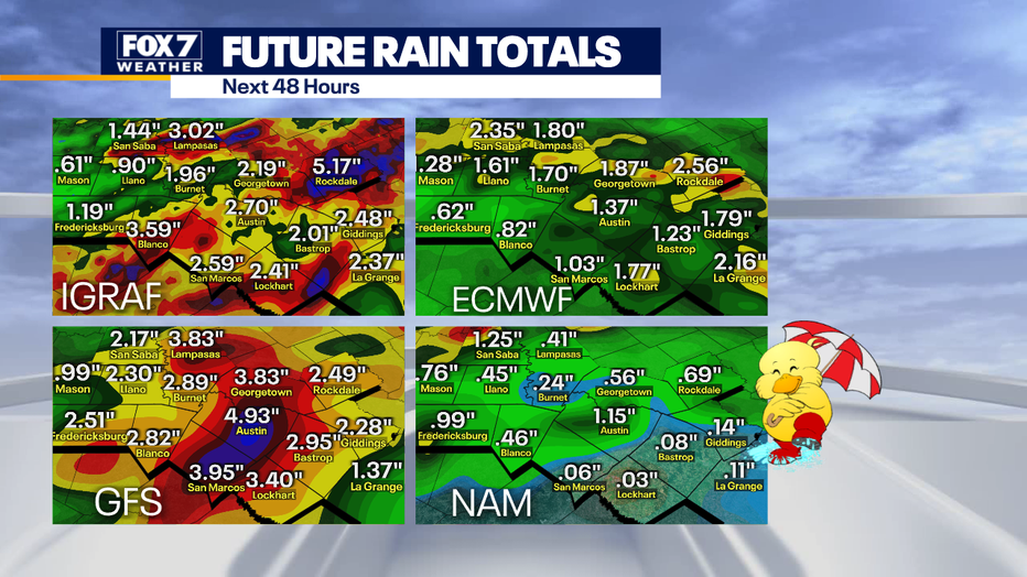
We are expecting a large complex of storms to form in the Hill Country along an outflow boundary left behind from this morning’s storms.
The area is under a slight to enhanced risk of severe storms with the highest threat over the Hill Country.
Timeline:
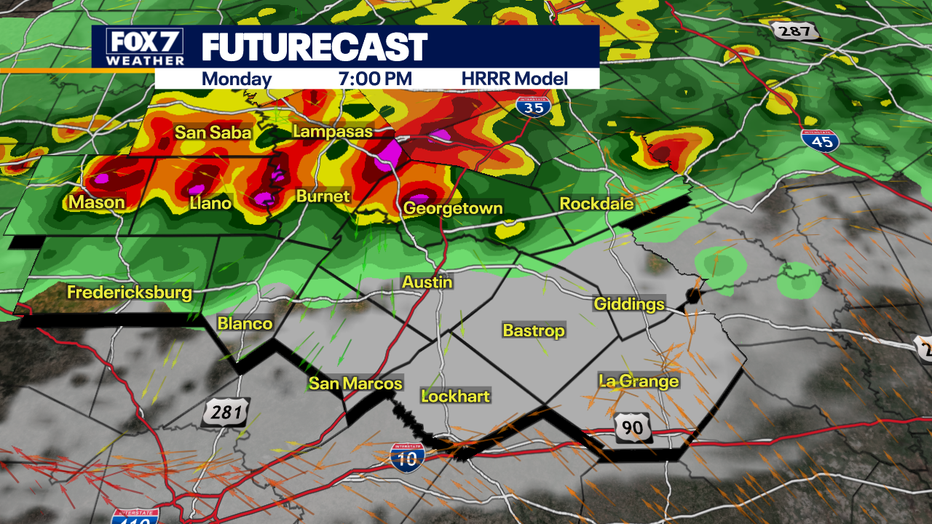
The storms are expected to hit the Hill Country between 5 p.m. to 9 p.m.
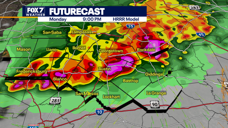
The Austin metro area can expect storms between 7 p.m. and 11 p.m. tonight.
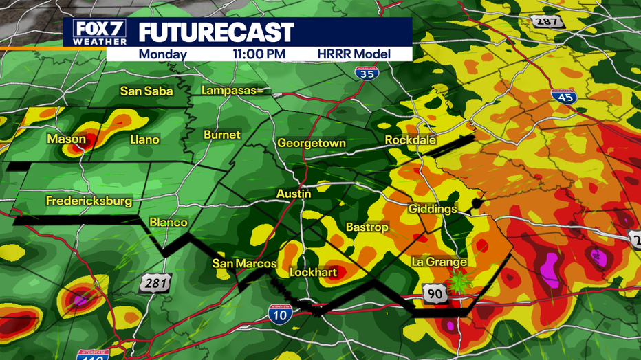
The Eastern counties will most likely see the storms between 9 p.m. and midnight.
Why you should care:
Look out for very large hail, damaging winds, lots of lightning and even isolated tornadoes can’t be ruled out.
Quarter to baseball-sized hail is possible from Austin to the Hill Country.
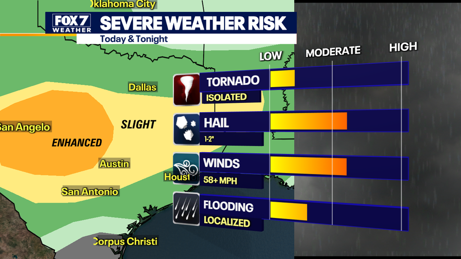
There is also the possibility of straight-line winds of 58 mph or more.
Flooding is expected to be mostly localized with street flooding the biggest concern.
What you can do:
If you’re out and about, it will be very important to pay close attention to the weather today.
Stay weather aware and track your local forecast for the Austin area quickly with the free FOX 7 WAPP.
The design gives you radar, hourly, and 7-day weather information just by scrolling. Our weather alerts will warn you early and help you stay safe during storms.
The Source: Information from meteorologist Zack Shields.