Severe weather metro Atlanta, north Georgia | Live updates Sunday, May 25
Severe thunderstorms watches and warnings issued for multiple north Georgia counties until midnight.
ATLANTA — UPDATE: This live weather blog is no longer being updated. Click here for updates into the early morning Monday hours.
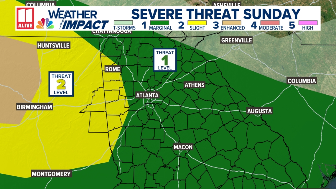
The 11Alive Weather Impact Team has issued a Weather Impact Alert for tonight as they continue tracking a line of strong storms that could bring damaging winds to metro Atlanta and parts of North Georgia. The alert is in effect through 3 a.m. Monday.
The Storm Prediction Center has expanded the Level 2 (Slight Risk) zone to include some parts of northwest Georgia, which means there’s a heightened chance for strong to severe storms in that area overnight. The rest of metro Atlanta remains in a Level 1 (Marginal) risk for severe weather.
A Severe Thunderstorm Watch is now in effect for Floyd, Chattooga, Pickens, Bartow, Gordon, Gilmer, Fannin and Polk counties until midnight. That watch may be expanded to include more counties as the night progresses.

Live weather updates for Sunday, May 25:
- 10:35 p.m. | The severe thunderstorm watch has been cancelled for Fulton, Paulding, Douglas, Dekalb, Carroll, Cobb, Gwinnett, and Haralson counties.
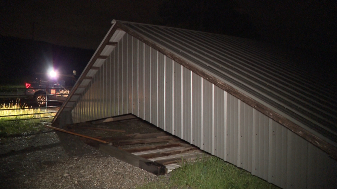
- 10:30 p.m. | A barn has collapsed in Bartow County in Cartersville after storms rolled through

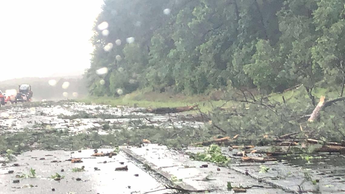
- 9:36 p.m. | Trees are down in I-75 in Bartow County near Adairsville, with some blocking the roadway.

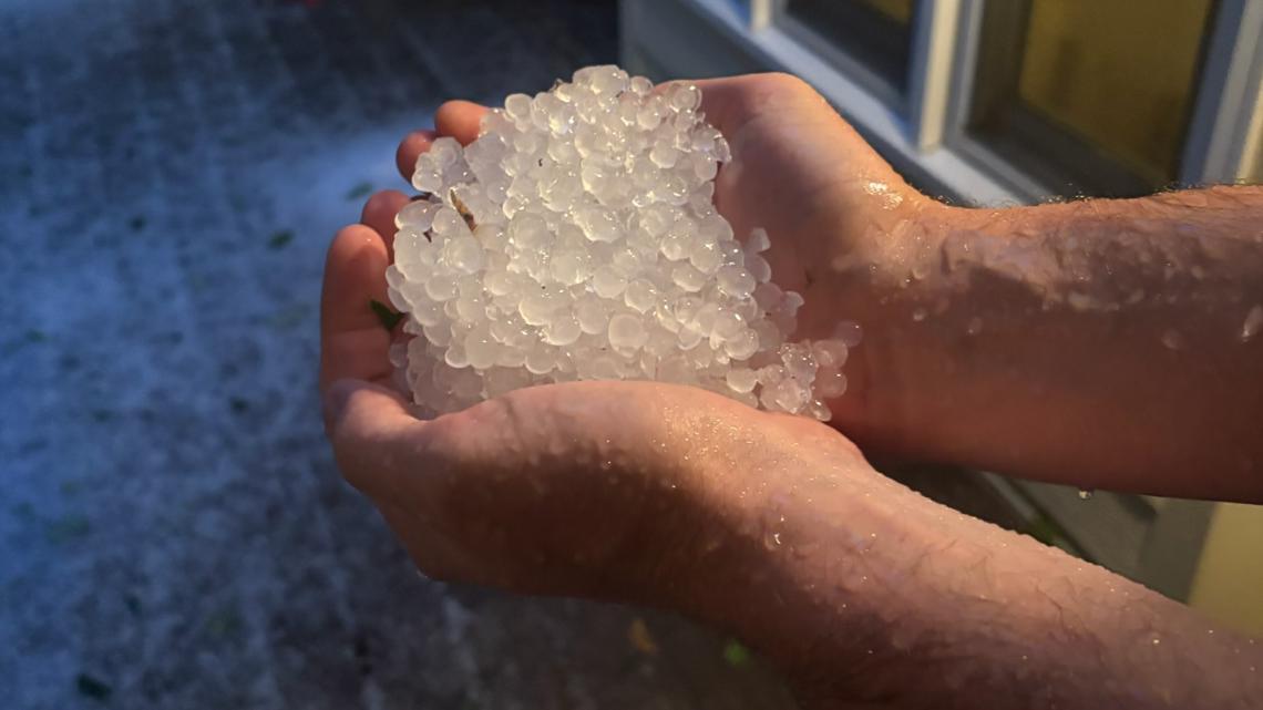
- 9:15 p.m. | Hail reported in Marietta

- 9:13 p.m. | Severe thunderstorm watch has now been cancelled for Pickens, Chattooga, Bartow, Gordon, Forsyth, Floyd, Gilmer, Fannin, Dawson, Union, Cherokee, and Polk counties.
- 8:57 p.m. | Severe thunderstorm watch issued for Cleburn and Randolph County, Alabama until 3 a.m.
- 8:43 p.m. | Several trees are down in the Cartersville area, according to local officials.
- 8:29 p.m. | Severe thunderstorm warning issued for Fulton, DeKalb, Cobb, and Gwinnett counties until 9:15 p.m.
- 8:04 p.m. | Severe thunderstorm warning issued for Fulton, Forsyth, Cherokee, and Cobb counties until 8:30 p.m.
- 7:43 p.m. | Highway 255 at Couch Road is shut down in south Murray County due to a large tree blocking the roadway.
- 7:39 p.m. | There are reports of multiple trees down in the area of Spring Creek Road and Burton Road in Chattooga County.
- 7:38 p.m. | Severe thunderstorm warning issued for Pickens, Bartow, Floyd, Gilmer, and Cherokee counties until 8:15 p.m.
- 7:25 p.m. | Severe thunderstorm watch issued for Fulton, Paulding, Forsyth, Douglas, Dawson, DeKalb, Union, Carroll, Cherokee, Cobb, Gwinnett, and Haralson counties until midnight.
- 7:13 p.m. | Tornado warning issued for Bartow and Gordon counties until 7:30 p.m.
- 7:08 p.m. | There are reports of multiple trees down in Chattooga County in the area of Mountain View Road and Spring Creek Road.
- 6:56 p.m. | Tornado warning extended for Gordon and Floyd counties until 7:15 p.m.
- 6:49 p.m. | Severe thunderstorm warning issued for Chattooga, Bartow, Gordon, Floyd, and Gilmer counties until 7:30 p.m.
- 6:43 p.m. | Tornado warning issued for Chattooga and Floyd counties until 7 p.m.
- 6:17 p.m. | Severe thunderstorms watch issued for Pickens, Bartow, Gordon, Gilmer, Fannin and Polk counties until midnight.
- 6:12 p.m. | Severe thunderstorm warning extended until 7 p.m. for Chattooga County.
- 5:29 p.m. | Severe thunderstorm warning issued for Chattooga County until 6:15 p.m.
- 4:25 p.m. | Severe thunderstorm watch issued for Floyd and Chattooga counties until midnight.
MORE FROM THE 11ALIVE WEATHER IMPACT TEAM
DOWNLOAD THE 11ALIVE APP:
- Download the app on your Apple or Android device.
- Set up weather notifications by clicking the Gear icon in the upper right corner of the app. Select Notification -> Notification Settings -> Severe Weather Alerts -> Toggle the Severe Weather Alerts button to the right to turn alerts on.
- Send photos and videos through the app by selecting the Near Me feature on the bottom right taskbar of the app and entering your information.
TEXT YOUR WEATHER PHOTOS TO US: 404-885-7600
JOIN THE 11ALIVE WEATHER IMPACT TEAM’S FACEBOOK GROUP: Nearly 10,000 metro Atlanta and north Georgia weather enthusiasts share their weather photos every day. Click here to join the group!